
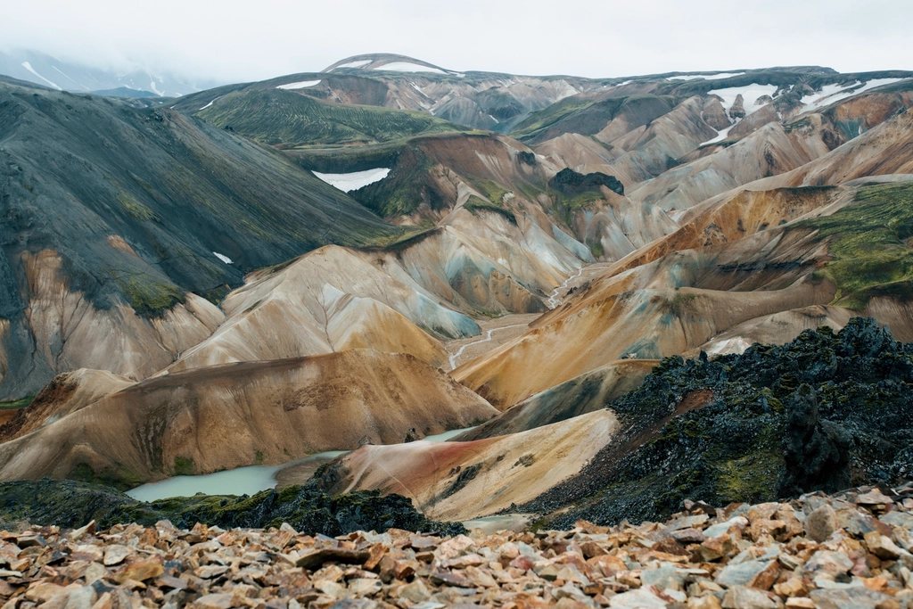
The interior of Iceland is a desert of black sand, lava and glacial rivers, uninhabited, closed by snow for nine months of the year and crossed by a handful of gravel tracks. Those tracks are the F-roads, and for a couple of months each summer they offer some of the starkest bikepacking in Europe. Kjolur, the track that runs between the two great glaciers of the west, is the one to start with. This is what it is like, how it fits with the wilder routes, and what the interior demands from a loaded bike.
What an F-road is
An F-road is a mountain road that is open only in summer, unpaved, often crossed by unbridged rivers and legally restricted to four-wheel-drive vehicles. Bikes are allowed. The roads open when the road authority declares them passable, usually between mid June and early July depending on snowmelt, and close in September or with the first autumn storms. Riding anywhere off a marked track is illegal throughout Iceland, because the moss and sand take decades to recover from a single wheel mark; the rule applies to bikes as much as to vehicles, and it is taken seriously. A sensible rule for us is that if we cannot ride the track, we push on the track.
Kjolur: the gentle one
Kjolur, the ancient route across the plateau between the Langjokull and Hofsjokull ice caps, runs for roughly 170 km from the waterfall at Gullfoss in the south to the northern ring road near Blonduos. Its historical status is real: it was used on foot and horseback for a thousand years, and outlaw legends attach to its huts and hot springs. Its practical status is what matters to a cyclist: all the major rivers are bridged, the gradients are gentle, and the surface is a compacted gravel that rides well when dry and turns to washboard where the tourist traffic is heaviest.
From Gullfoss the track climbs slowly onto the plateau, passing the lake and hut at Hvitarnes with the glacier snout in view, then rises to around 700 m at its highest point. Halfway across is Hveravellir, a geothermal field with fumaroles, a bathing pool of warm water, a hut and a campsite, and the natural place for the middle night. The northern half descends gradually along the Blanda river toward green farmland and the coast. Two days is a common plan; three lets you detour to the glacier edge and spend a lazy morning in the hot pool. In good weather it is a joyful ride. In a northerly wind with rain it is a grim, cold grind across nothing, and both versions happen in the same week.
The harder tracks: Sprengisandur and Fjallabak
Once Kjolur is done, the interior opens up. Sprengisandur is the long one, about 200 km of black desert between Hofsjokull and Vatnajokull, the largest ice cap in Europe, with a single hut at Nyidalur near the midpoint at about 800 m. Unlike Kjolur it has fords, some of them wide and cold enough to demand care, and there is no shelter from wind for a very long way. Water can be scarce on the sand between rivers. It is a two to four day commitment with nothing to buy and nowhere to hide.
Fjallabak, the region behind the southern glaciers, is more varied and more popular: rhyolite mountains in yellow, red and green, obsidian lava, hot springs and steaming valleys. The tracks in from the south and west converge on Landmannalaugar, at about 600 m, with a large campsite and a natural warm river to sit in. From there a chain of tracks and fords continues east and south. Landmannalaugar is also the starting point of a 55 km hiking trail south to a birch-wooded valley under the glaciers, which is walked rather than ridden; a bike-and-hike plan that leaves the bike at the campsite for two or three days of walking works well here.
Weather, water and daylight
Summer in the highlands means daytime temperatures between 5 and 15 degrees, rain on any day, and wind that is the real adversary. Sand storms happen on the black deserts, and a strong headwind can reduce a fit rider to walking pace for hours. Snow is possible in July at altitude. We pack for a cold, wet week in Scotland and add a neck tube, glacier sunglasses and full-fingered gloves, and we pitch the tent in the lee of something, or inside the low stone windbreaks that some campsites provide.
Water is plentiful but comes in two kinds. Glacial rivers are grey with silt and unpleasant to drink; clear streams and springs from lava fields are among the cleanest water anywhere and need no treatment. Fill from the clear ones and carry 2 to 3 litres between them. Daylight is not an issue: in late June it barely gets dark, and even in August there is light until late in the evening, which makes it possible to sit out the afternoon wind and ride at night.
Bike, load and logistics
- Tyres: 50 mm or wider; sand and washboard punish narrow tyres, and a low bottom gear is more useful than suspension.
- Fords: unclip, walk the bike, face slightly upstream, and cross early in the day when glacial rivers are lowest; if the water is above the knee and fast, wait or turn back.
- Food: there is nothing to buy in the interior; carry everything from the last town, and expect four to six days of food for Sprengisandur with a margin.
- Huts and camping: mountain huts run by touring associations are basic, warm and bookable, and their campsites are the only legal camping inside protected areas; elsewhere a single night in a tent on wild ground is generally tolerated.
- Transport: scheduled summer highland buses cross Kjolur and reach Landmannalaugar and carry bikes, which lets you ride one way and return by bus.
- Fuel: gas canisters are sold in towns and at some huts; carry more than you think, as the wind doubles cooking times.
Why it is worth it
There is no other landscape in Europe like it: a place where a bicycle can cross a hundred kilometres of ground with no trees, no buildings and no soil, between ice caps that fill the horizon. Kjolur is the way in, the F-roads beyond are the reward, and the weather is the price. We think it is a fair one.